Locating addresses
An address looks simple because most of the work has already been done. A number and road name can usually take a courier, ambulance, council officer or mapping application to one recognisable place. Inside a GIS, however, that apparently ordinary description depends on several different records agreeing with one another. The road needs a name and a geometry. The address needs a number or other identifier and some relationship to that road. A property record may need to be linked to it, and a cadastral parcel may sit beneath it without being the same thing. By the late twentieth century New Zealand organisations were increasingly trying to make those relationships computable rather than relying on paper street lists, local knowledge and separate agency files.
Chapter 16 followed the statistical geography that divided the country into areas for counting people. Address data solved a related but different problem. A census meshblock could tell an analyst which polygon contained a population, but an individual dwelling or administrative record still had to be assigned to that polygon. Emergency services had an even less forgiving requirement: a caller could supply an address, road name or place name and expect Police, Fire or ambulance services to find the location. Councils needed addresses for property administration and service delivery. Electoral officials needed to know where an address fell in relation to an electorate. Postal systems needed delivery locations. These users shared a broad interest in place, but they did not begin with one common national database.
The records were also created for different reasons. Territorial authorities named roads and allocated property numbers under local-government law. The cadastral system recorded surveyed parcels and legal interests in land. Rating and valuation systems grouped land and improvements according to administrative requirements that did not always match parcel boundaries. Postal addresses were designed for delivery. Statistical geographies divided population for enumeration and aggregation. GIS made it possible to connect these records, but it did not erase their different origins or guarantee a tidy one-to-one relationship among them.
Roads and addresses
A road centreline is a spatial representation of a transport route. It can carry a road name, road class, direction and other attributes, and it can support navigation or network analysis. An address identifies a location associated with that road, normally through a number and name and often a suburb, locality or town. A parcel is a cadastral unit. A property used by a council or valuer can combine or divide cadastral parcels according to administrative requirements. A building or unit can introduce still another relationship. One parcel can contain several addresses, one address can serve several units, and a property used for rating does not have to reproduce a legal survey boundary exactly.
This distinction was already visible in digital land information. The Digital Cadastral Data Base described in Chapter 13 was principally a parcel framework, but road centrelines and street-address information were maintained as related information rather than treated as part of the legal parcel geometry itself. Historical LINZ documentation later described street-address data being updated from advice supplied by territorial authorities and road names being managed through the Authoritative Streets and Places database. The cadastral database could help locate an address and provide a parcel relationship, but it was not an address database simply because both described the same piece of ground.
For GIS users in the 1990s, these distinctions often appeared as a data-integration problem. A council might have a property or rating identifier, a parcel layer, a street number and a road name in different tables. A health service or business might hold a customer address but no coordinate. A national dataset might provide a road centreline without the local property information needed to decide which driveway or building was intended. Much of the practical work lay in creating relationships among these records and keeping them current when roads were renamed, subdivisions created new addresses or parcels changed.
Local records, national need
Sources · 1
2. Local and national responsibility. Use historical DCDB material and later LINZ addressing guidance to support territorial authorities allocating road names and property numbers and the national land-information organisation collating, checking and redistributing the national record. Do not back-project every detail of the modern workflow into the 1990s.
The basic institutional arrangement placed much of address creation close to the ground. City and district councils allocated road names and property numbers. That made sense because subdivision, building and road changes were local events, and councils were often the first public bodies to know that a new street or address existed. National users, however, needed those local decisions to be collected consistently. Electoral administration, Statistics New Zealand, central government, emergency services and later national web and GIS applications all depended on address information that crossed council boundaries.
The Surveyor-General acquired an important collation role within that arrangement. Under the Local Government Act framework, territorial authorities were required to advise the national land-information system of allocated or changed road names and property numbers. Later LINZ guidance describes the national record as being maintained from those local notifications, with the central agency checking information against addressing standards and incorporating it into national address and road data. Councils allocated addresses within the shared framework. It was a distributed production system in which local authorities assigned much of the information and a national custodian assembled, checked and redistributed it.
That workflow was inherently geographic. A new road name had to refer to the correct road. A property number needed a meaningful position along it. The locality or suburb needed to distinguish the address from similar names elsewhere. An address also had to be related to the right electoral, statistical and local-government areas. Errors that looked small in a database could become operationally large when a record was assigned to the wrong road, a road name was duplicated or an emergency crew was sent toward the wrong end of a rural route.
The emergency problem
Sources · 1
1. Emergency Services Address. Use the LINZ Emergency Services Address specification, accepted 9 November 2001 and recovered as version 1.9.7 published in April 2004. It defines a shared core dataset around address data, road-network data and place-name data. Treat it as a national digital-standardisation milestone, not as the invention of addressing or the first national address database.
Emergency response provided one of the strongest reasons to make this fragmented geography consistent. The Emergency Services Address work undertaken around 2001 reflects Police and Fire requirements for dependable digital location information. A call taker needed to turn a place description into a location that a dispatch system and responding crew could use. The required information went beyond a list of postal addresses. It included roads, place names and enough spatial structure to verify that the location supplied by a caller made sense.
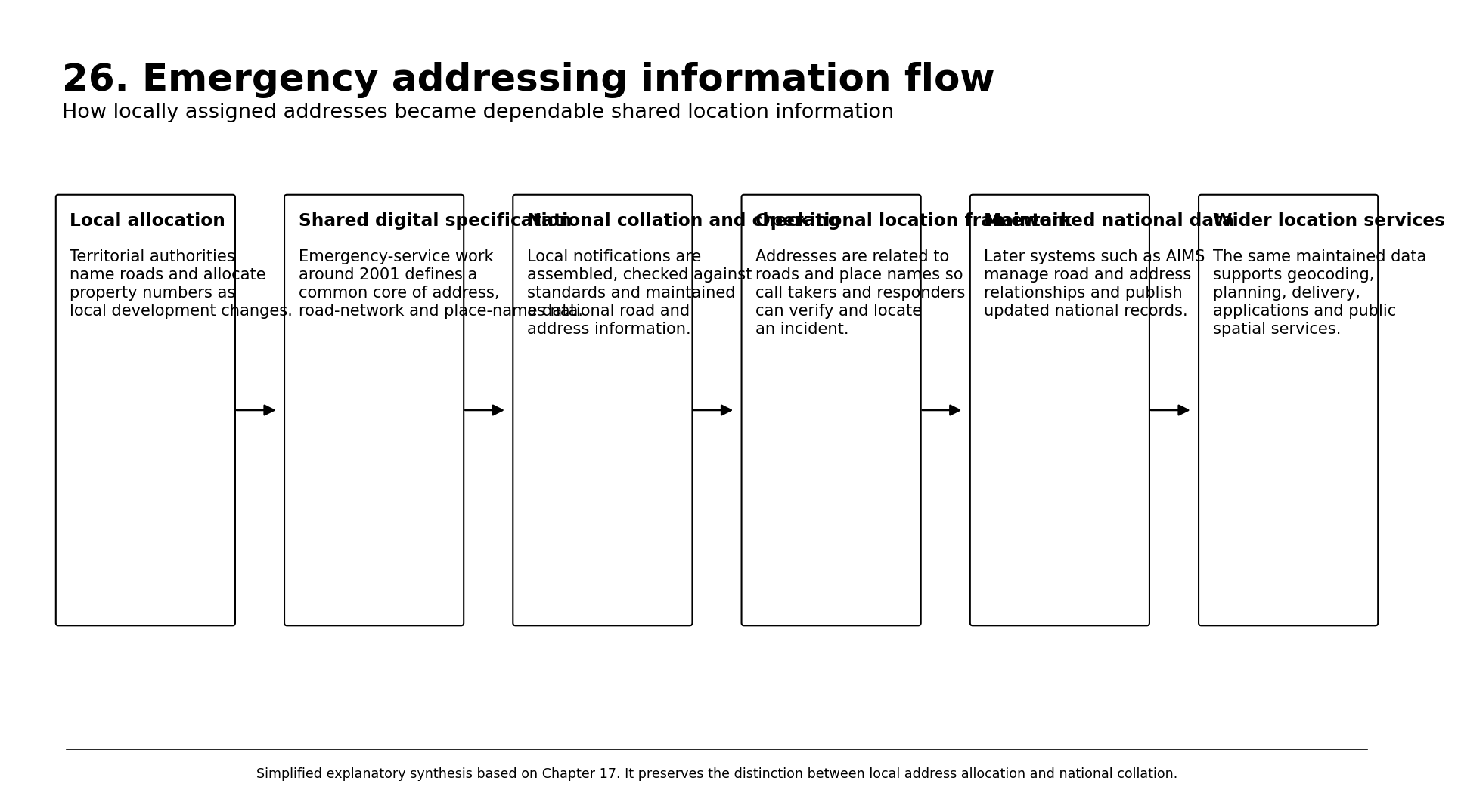
Image source · EX26-V01
NZ GIS History project, 2026. Simplified explanatory synthesis based on Chapter 17.
The Emergency Services Address, or ESA, programme made that requirement explicit. A data specification signed on 9 November 2001 brought together LINZ, New Zealand Police, rural fire and Statistics New Zealand participants. LINZ’s April 2004 version 1.9.7 defined a common core geospatial dataset for locating and verifying emergency events. Its acceptance statement described three minimum components: address data, road-network data and place-name data. The same information was also intended to provide a locational framework for wider government services.
The document is a useful snapshot of a national problem becoming a standards problem. Police did not need a cartographically attractive street map for its own sake. Fire did not need a cadastral database simply because parcels were available. Both needed enough authoritative location information to interpret an address or place, verify it against a road network and pass a usable location into emergency response. LINZ supplied national mapping and survey responsibilities, while Statistics New Zealand represented another large user of consistent geographic references. The specification therefore sat at the intersection of mapping, local addressing and operational information systems.
New Zealand addressing work preceded the 2001 agreement. Councils, postal services, electoral officials and emergency organisations had used addresses for generations. The milestone was the explicit specification of a shared digital core across agencies. It converted a collection of familiar location concepts into a common geospatial framework whose records could be maintained, exchanged and reused. That is a different historical claim from saying one organisation invented a national address system on one date.
Roads for response
Road geometry helped crews navigate to the location identified by an address. The same road can be long, interrupted, renamed or locally ambiguous. A digital road network provides the structure within which address locations and place names can be interpreted. For emergency services it also supplies the basis for route finding, checking intersections and distinguishing similarly named roads in different districts. The road layer therefore became more than a cartographic backdrop to address points.
Maintaining the road information posed the same institutional problem as addresses. Councils knew about local road creation and naming. National land-information systems needed a consistent road record. Emergency services needed rapid updates when a new subdivision or changed road name entered everyday use. The later AIMS environment made this relationship more explicit by managing national address information alongside improved national road data. By 2016 LINZ was publicly describing a new roads database that could accept geometries from council-supplied spatial files, check road-name conflicts and align road geometry with the direction of addressing.
The later system brought these elements together. Earlier DCDB-related standards, electoral street records, Statistics New Zealand products and emergency-service work all contributed to the lineage. AIMS represented a more mature centralised management environment, not the moment when roads or addresses suddenly became digital.
Source notes
The project evidence does not yet support a single launch date for the first national digital road or address database.
Rural distance becomes an address
Sources · 1
3. RAPID and addressing standards. Use Mackenzie District Council's documented 2001 RAPID implementation as an example, not a national first. Use the 2003 Australian/New Zealand rural and urban addressing standard and its 2011 replacement for the national standards lineage and the distance-based numbering method.
Rural addressing exposed the weakness of relying on familiar urban street numbering. A farmhouse might sit many kilometres along a road with no dense sequence of neighbouring numbers and few obvious landmarks. Emergency crews travelling at night could lose considerable time if the caller’s location depended on a farm name or directions such as a turn after a particular bridge. Rural Address Property Identification, commonly known as RAPID, addressed this by tying the number to distance along the road. Accurate entrance locations helped emergency services find rural properties.
Under the familiar RAPID method, a number is calculated from the distance in metres from the defined start of a road to the property entrance, divided by ten, with odd and even numbering used for opposite sides. A property numbered 500 is therefore about five kilometres from the road’s start rather than merely the five-hundredth lot. Councils allocate the number, and the entrance rather than the cadastral centre of the property is normally the operational location. The method makes the number itself useful to someone travelling along the road, especially where houses are widely separated.
Councils introduced the scheme through local implementation. Mackenzie District Council, for example, records implementing RAPID in 2001 to replace rural fire numbers. The approach was incorporated into the Australian/New Zealand rural and urban addressing standard issued in 2003 and subsequently revised. Police guidance later described RAPID as a nationwide system for helping emergency services locate rural properties. Distance-based rural addressing spread during the late 1990s and early 2000s.
RAPID also demonstrates that an address carries location and access information beyond the parcel label. The operational reference point is the entrance from the road. A large rural title can have more than one entrance and therefore more than one useful access location. Several dwellings can share an entrance. A number that helps an ambulance reach the correct gate can be more operationally useful than the centroid of the legal parcel. Digital GIS made it possible to preserve both relationships rather than choosing one geometry and pretending it served every purpose.
Address standards
Emergency-service requirements were only one part of a broader move toward consistent addressing. An address had to work for someone reading it on an envelope, a council officer maintaining a property record and software trying to match it against a national database. Small local differences could create large national complications. Road types might be abbreviated differently, duplicated road names might be harmless within one district but ambiguous in a national search, and subdivision could leave several properties competing for numbers between two existing addresses. Consistency therefore depended as much on allocation rules as on database technology.
The Australian/New Zealand rural and urban addressing standard introduced in 2003 provided a common framework for territorial authorities and other users. Its later 2011 replacement covered the assignment of addresses, road naming, recording and mapping information, and signage. The aim was to identify properties clearly and unambiguously. Familiar conventions such as odd and even numbers on opposite sides of a road, and distance-based numbering in rural areas, became part of a nationally recognisable approach rather than a collection of unrelated local customs.
This standardisation also clarified the difference between allocating an address and recording one. Councils remained responsible for naming roads and assigning property numbers. The national land-information organisation received those decisions, checked them against the relevant standards and maintained the official record. A database could therefore reject or query an allocation that created ambiguity without claiming the legal role of the council that made the original decision. The workflow combined local authority with national quality control.
The distinction became more useful as software increasingly treated an address as structured data rather than one line of text. Number, road name, road type, unit information, suburb or locality and territorial authority could be stored separately and recombined for display. A unique identifier could preserve the identity of the address even when some text changed. A road could likewise have an identity distinct from its displayed name or geometry. This reduced dependence on exact string matching and made it easier to propagate changes across linked systems.
Some addresses remained ambiguous even within a structured system. A retirement village, shopping complex or apartment building might contain several independently useful delivery or emergency locations inside one cadastral parcel. A corner property could have relationships to more than one road. A rural property might have several gates that mattered operationally. The data model therefore had to represent the location people actually used as well as the legal land beneath it. National consistency worked best when the system preserved those differences instead of forcing each property into one number, one point and one parcel.
Property is another geography
Property information created similar ambiguity in towns and cities. A cadastral parcel is defined through the survey and title system. A council rating unit or valuation property is created for rating and valuation administration. A building can cross internal parcel relationships or contain multiple separately addressed units. An apartment building can produce many addresses at almost the same coordinate. These are not data errors merely because the records do not align one for one.
A late-1990s Waikato project provides a small example of the practical problem. The 1998 University of Waikato report by Duane Wilkins and Lex Chalmers, commissioned for Waikato District Council used property boundaries and relational records to analyse subdivision and land fragmentation in the Tamahere study area between 1989 and 1998. The application used parcel and property information for work beyond title administration. Once boundaries could be linked to records over time, a council question about subdivision could be analysed as changing spatial structure rather than answered from separate plans and tables.
The same joining problem later appeared in national data. Modern LINZ address data can carry relationships to parcels, but those relationships need careful interpretation where unit titles, shared accessways or complex developments are involved. Valuation and rating datasets introduce another set of identifiers. For GIS practitioners, the practical lesson developed through repeated integration work: parcel ID, property ID and address ID are useful precisely because they identify different things. A robust system links them where appropriate rather than replacing one with another.
From street list to geocoding
Sources · 1
4. StreetLink. Use the Statistics New Zealand Census Meshblock Dataset Guide and StreetLink documentation for linking street names and address ranges to meshblocks and larger official geographies. Use the 2007 government pricing record for NZ$6,000 plus GST first supply, NZ$2,000 annual update and NZ$250 quarterly update before the standard file became free on 7 July 2007.
Statistics New Zealand’s StreetLink product provides a useful bridge from Chapter 16 into the address story. StreetLink related street names and address ranges to meshblocks, area units and territorial-authority geographies. A database user could take an address held in a customer or administrative system and assign it to an official statistical area without manually locating every record on a map. The associated Streets file listed address ranges and street names within meshblocks, while Areas files provided the relationship from meshblocks to larger geographies.
The service matched addresses with geographic locations for administrative use. The task was to interpret an address consistently enough to attach an official geographic code. For a health service, council, market analyst or government agency, that could turn a table of customers or cases into population-based spatial analysis. StreetLink also depended on the maintenance of both street information and statistical geography, making it a clear example of two national data systems being connected rather than one replacing the other.
Access remained a separate issue. Before July 2007, the standard StreetLink file was a paid Statistics New Zealand product. The government pricing record lists NZ$6,000 plus GST for the first supply, NZ$2,000 for an annual update, or NZ$250 for a quarterly update. On 7 July 2007 the standard file became free, removing a direct acquisition cost for organisations wanting to connect their own address records to official geography. The underlying data and geocoding method already existed.
That example parallels the census-boundary story without repeating it. A useful national linkage dataset could exist for years while access remained specialised and priced. Making the standard file free widened the potential user base, but organisations still needed clean addresses, matching routines and staff who understood the resulting codes. Removing the invoice did not remove the work.
Maintaining one national record
By the 2010s LINZ’s Address Information Management System, or AIMS, provided a centralised environment for managing national addresses, including information needed for electoral purposes. Territorial authorities remained the source of allocated addresses. LINZ incorporated those notifications into the national record, maintained road and address relationships and published data for wider use. The architecture preserved the long-standing institutional split between local allocation and national collation while replacing more fragmented exchange with a managed database environment.
The public data also became more explicit about identity. Address records could carry unique identifiers rather than depending entirely on a formatted text string. That is useful because the wording of an address can change while the underlying location relationship continues, and two systems can format the same address differently. Persistent identifiers allow databases to compare and update records without relying only on spelling. Road and address records could also be related to territorial authorities and parcels, making the national dataset useful as a linking layer across otherwise separate information systems.
Quality remained dependent on the chain of contributors. A national database cannot know about a new subdivision until the responsible local information reaches it. A road name can be legally correct but still confusing if a similar name already exists nearby. A point can be placed on the correct parcel but at a location that is poor for navigation. LINZ guidance therefore emphasised standardised allocation, notification and checking rather than treating addresses as coordinates that could be generated automatically from parcel geometry.
Distribution also changed. The LINZ Data Service, launched in 2011, progressively made national land and location data easier to obtain and reuse. Address and road datasets later became openly downloadable and available through web services and APIs, with regular updates. This wider open-data transition belongs principally in Chapter 33, but its effect on addressing was straightforward: an authoritative national address record could increasingly be built directly into council systems, applications and GIS workflows without the older product-ordering model.
Public address data
The mature endpoint is visible in the way national address data is now consumed. The official record is published as reusable point and road data and updated frequently. Users can download complete datasets, call services or maintain local copies from regular changes. A council, emergency organisation, utility, delivery service or software developer can build its own application around the same national identifiers rather than retyping a separate address list from scratch.
That reuse also made inconsistencies more visible. OpenStreetMap contributors imported large numbers of LINZ address points beginning in 2017 and later developed routines to reconcile ongoing changes. The exercise exposed duplicate coordinates, apartment and unit complexities, missing records and the general difficulty of keeping two independently maintained address systems aligned. The comparisons identified continuing data-maintenance work. Comparing millions of records exposed errors and inconsistencies that required continuing maintenance.
The modern national dataset has continued to evolve. NZ Addresses replaced the older NZ Street Address product in 2023, while road and locality products have also been revised. Fire and Emergency New Zealand’s locality information, originally maintained to help responders locate emergency calls, was transferred into LINZ stewardship in the 2020s. These later changes sit beyond the chapter’s main period, but they complete the institutional pattern established two decades earlier: location information created for one operational purpose can become shared national infrastructure when common standards, maintenance responsibilities and distribution mechanisms are strong enough.
The people maintaining place
None of this geography maintained itself. Council staff named roads, allocated numbers, assessed subdivisions and corrected local records. LINZ staff checked notifications, maintained national address and road databases, managed standards and reconciled relationships with cadastral and electoral information. Statistics New Zealand staff maintained street-to-statistical-area links. Police, Fire and rural-fire specialists supplied operational requirements for locating incidents. Postal organisations and commercial data suppliers maintained their own delivery and value-added products. GIS technicians, database administrators and quality-control staff kept the exchanges working between them.
The ESA specification makes that institutional breadth unusually visible. Its 2001 acceptance was signed across mapping, survey, Police, rural fire and statistical roles rather than by a single GIS team. The document described minimum shared data because each organisation already had its own operational responsibilities. Standards work was therefore a form of systems integration. The difficult part was agreeing which parts of several organisations’ geography had to mean the same thing when an emergency call or government record crossed their boundaries.
Errors and exceptions remained part of the work. A duplicated road name, a late council notification, a rural entrance moved after subdivision or several unit addresses sharing one coordinate could all create problems that software alone could not resolve. Quality control required knowledge of local-government decisions, cadastral relationships, road geometry and operational use. Addressing was a national database problem built from thousands of local decisions.
Coordinate limitations
By the time address and road information had become widely reusable digital infrastructure, another change was altering how locations entered these systems. Earlier address databases were assembled mainly from maps, council records, survey information and manual coding. Increasingly, field staff could capture a coordinate directly with satellite positioning. Rural address entrances, assets, incidents and new features could be observed in the field rather than inferred only from existing plans.
Addresses remained useful for identifying places and communicating locations. A coordinate can identify a position, but people still communicate through road names, numbers, suburbs and localities. Emergency services still need an address that can be spoken over a telephone and recognised at a gate. Property systems still need relationships to parcels and administrative identifiers. Satellite positioning added another way to establish where something was; it did not replace the institutional geography that told users what the place was called and how it related to other records.
That positional change was already under way. GPS and later GNSS moved coordinate capture from specialist survey networks into field operations, vehicles, handheld receivers and eventually ordinary devices. Roads, addresses and property records gave New Zealand an increasingly consistent language for named and administrative location. Satellite positioning made the coordinates themselves increasingly immediate.