Image archive Image details
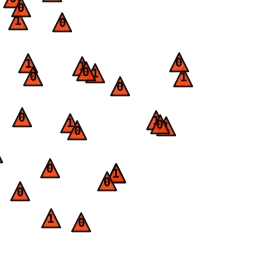
LINZ TileMill geodetic marks layer preview (2015)
About this image
This is a genuine original GIS map-layer preview for the geodetic-mark symbol layer in LINZ’s TileMill-based national terrain basemap project. It documents a 2015 GIS publishing workflow. It is not a full map export, a standalone GIS application screenshot, or proof of an earlier launch. Archive-only until a separate, paragraph-level placement review.
Download the original locally stored image
Attribution
Source and reuse
- Credit
- Crown copyright, Land Information New Zealand and New Zealand Government. Original LINZ TileMill map-layer thumbnail from the project’s 2015 Git history; locally resized WebP derivatives.
- Image date
- First recorded in LINZ Git history by 25 May 2015; rendering/capture date not stated
- Original file source
- View the source-original image
- Original source filename
- SupportingLayers/GeodeticMarks/.thumb.png
- Original dimensions
- 256 × 256 pixels
- Original SHA-256
65333d6b8443a0caeb2a71fa19f2b7f8518686a7e8c4167a53343bf93688c01e- Reuse conditions
- Publisher's licence statement
- Display preparation
- Original .thumb.png bytes preserved unchanged at the original path. Display and card files are WebP conversions without upscaling or cropping. Source Git blob SHA-1 and local SHA-256 recorded.
- Local copy
- The reader displays a local copy so the image remains available if the original page changes.