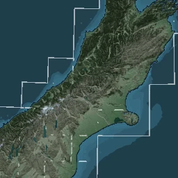
National 8 m raster elevation model built by Geographx mainly from LINZ Topo50 20 m contour data.
Geographx's 8 m national digital elevation model was compiled primarily from LINZ Topo50 20 m contour data, with point heights, interpolation and supplementary processing around waterways and coastlines. Roger Smith's 2012 account identifies it as the terrain source for the company's separate 4 m land-cover raster basemaps.
Sources · 2
- LINZ Data Service, NZ 8 m Digital Elevation Model (2012)
- Roger Smith, Designing Raster Base Maps with Photoshop, 8th Mountain Cartography Workshop, 2012, pp 101–106
LINZ made the model available for reuse under a Creative Commons licence; the 2015 New Zealand Cartographic Society report distinguishes this open elevation model from Geographx's commercial natural-colour basemap. An 8 m grid interval is the raster spacing, not a claim of 8 m vertical or positional accuracy. The contour-derived surface was designed principally for cartographic visualisation, not for detailed terrain analysis, including precise hydrological, geotechnical or site-level modelling.
Sources · 2
- LINZ Data Service, NZ 8 m Digital Elevation Model (2012)
- New Zealand Cartographic Society, Cartographic Activities in New Zealand 2011–2015, ICA national report, p 14
Later cartographic services reused this elevation resource. LINZ's published basemap reconstruction workflow calls for the 2012 8 m DEM and associated hillshade as inputs to TileMill alongside Topo50 and LCDB3.3. GNS and regional council services have also cited the Geographx model as a hillshade or terrain source. These downstream displays should not be mistaken for the separate original 4 m commercial imagery.
Related source links · 4
- LINZ licensed 8m DEM
- Roger Smith's 2012 design paper
- LINZ 2013 basemap reconstruction
- Related chapter
Sources and further reading · 4
- LINZ Data Service, NZ 8 m Digital Elevation Model (2012)
- Roger Smith, Designing Raster Base Maps with Photoshop, 8th Mountain Cartography Workshop, 2012, pp 101–106
- New Zealand Cartographic Society, Cartographic Activities in New Zealand 2011–2015, ICA national report, p 14
- LINZ, linz_basemaps 2013 reconstruction source, data inputs, TileMill workflow and CC BY 3.0 NZ terms
Indexed passages
- Company staffCompanies and user groups
- Terrain becomes dataMapping in 3D